This week we go east of Bruce Rock (our last destination) and cross the far eastern boundary of the wheatbelt. Our tour will be in 2 parts - Part 1 tonight where we visit Wave Rock, and then take the Granite and Woodlands Discovery Trail eastwards camping at The Breakaways and then north on 4WD tracks to Cave Hill. Part 2 on Tuesday or Wednesday we will travel south of Cave Hill to Peak Charles National Park.
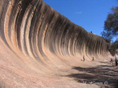
After leaving Bruce Rock our first stop is Hyden and Wave Rock on the far eastern edge of the wheat belt. 340 kilometres from Perth, thousands of tourists visit Hyden each year to see Wave Rock, a curved granite cliff face 15 metres high and 110 metres long in the shape of a curling wave caused by weathering and water erosion.
I had a more standard photo showing the magnitude of Wave Rock - but decided to use this one instead of some young people "surfing" the wave.
 |
| From Life Images by Jill |
Along the road we crossed the 1,837 kilometres long State Vermin Proof Barrier Fence initially constructed to keep the rabbits from invading Western Australia from the east.
The fence marks the eastern edge of the wheatbelt and we enter the vast low sandy kwongan heathland which stretches to the horizon and supports amazing plant diversity and a kaleidoscope of colour during the spring wildflower season including the flame grevillea which lines the road. The sand plains are far from barren and it is very interesting to see the many changes in vegetation along the track, dependant on soil types and climate.
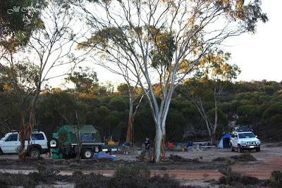
By late afternoon we are 136 kilometres from Hyden we pull off the road at the first designated camping spot, The Breakaways. Here is our campsite. We travelled with my son and daughter in law and our 2 grandsons - that's their camper trailer you can see in this photo. We are tenting - hope you have a good blow up mattress and have brought your marshmallows to cook over the fire.
 |
| From Life Images by Jill |
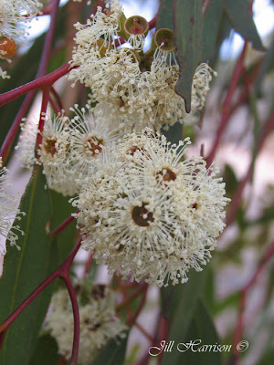
Here is a photo of the Ribbon Gum flowers.......
 |
| From Wildflowers |
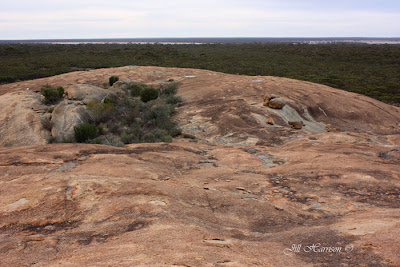
McDermid Rock has a designated camping place attractively located amongst the trees, and the 1150 metre rock trail features 18 interpretive panels. The first part of the trail goes up to the highest point of the rock. Interesting features are rock dwelling plants and the gnamma holes. These rock holes hold water for a long time after rain and are important for human and animal life during drought. The aboriginals would visit favoured holes regularly to keep them clean. Granite rocks like McDermid Rock were used throughout the wheatbelt by early explorers as places to camp, take their bearings and map their progress.
The view from McDermid Rock......those are salt lakes you can see on the far horizon.
 |
| From Life Images by Jill |
 |
| From Life Images by Jill |
From here we turned north onto Victoria Holt Road heading towards Cave Hill.
Victoria Holt Road is a well maintained dirt road traversing through gimlet woodland with a salt bush understorey.
There are bush tracks throughout this vast area known as “The Woodlines” – a network of hundreds of kilometres of abandoned tramway formations south of the Coolgardie/Kalgoorlie goldfields. 4WDrivers can explore the area by following the old formations – however it would be advisable to carry a GPS as amongst the network of tracks you could easily become lost.
 |
| From Life Images by Jill |
The train lines extended out into the bush into the timber cutting areas. The Woodlines network began near Kalgoorlie in 1899. From 1932 to 1938 Cave Hill was the main refuelling and rewatering camp for the Kurrawang Woodline run by the Goldfields Firewood Supply Company. Many hundreds of thousands of tons of wood were taken out of this region during that time so it was good to see that the regrowth of Salmon Gum and Gimlet has now reforested the land and there are a number of Nature Reserves, Conservation Parks and National Parks to visit and camp in throughout this region.
Cave Hill is an impressive granite monolith – 1 kilometre wide and 1.5km long, rearing 50 metres above the surrounding forests. Charles Cooke Hunt named Cave Hill for a hollowed out wind sculptured cave on the Western face. Prior to European settlement, the Ngajtu Aboriginal people passed through this area and camped at Cave Hill for thousands of years, so Cave Hill is an important indigenous cultural site.
 |
| From Life Images by Jill |
 |
| From Life Images by Jill |
Here is the classic look of Wave Rock that you see in the travel brochures -
 |
| From Life Images by Jill |
No comments:
Post a Comment
Thank you for stopping by. I hope you have enjoyed this tour around Western Australia. I look forward to hearing from you and thank you for taking the time to comment.